An El Niño which is associated with El Niño Southern Oscillation weather event, has formed across the Pacific Ocean. It is the warm phrase of the Southern Oscillation. La Niña is the cooler phase of the Southern Oscillation and represents the opposite extreme. The original name for El Niño was El Niño de Navidad — the Christmas Boy because El Niño due to its peak around December. So what causes an El Niño? In the Pacific, trade winds blow westward across the equator, taking warm water from South America to Asia. This causes upwelling or when cold and nutrient rich water rises to replace the missing warm water. This process brings nutrients to the ocean. During El Niño, the trade winds weaken as warm water returns to the American coast. This stops nutrients from getting to the surface.
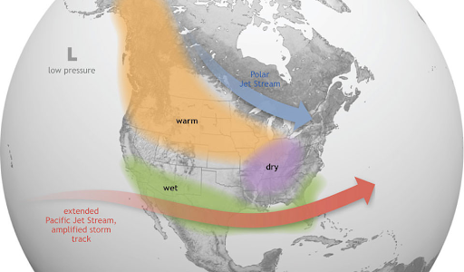
El Niño and La Niña last around 9-12 months, every 2-7 years. El Niño can impact weather, wildlife, ecosystems, and economics. The effects vary on the region of the world; causing flooding or droughts as the whole atmosphere shifts. Currently, the NOAA predicts that El niño will have a 75% to become a “strong” event lasting from November to January. But, what about California? The effects vary on location. Northern California may expect slightly warmer or wetter weather, or no difference depending on where the Pacific Jet Stream sets in. However, Southern California can expect above-average precipitation this winter. Keep in mind that the weather is unpredictable and it could mean average precipitation this winter. If there is more precipitation in Southern California, it would promote erosion landslides and affect terrestrial and marine ecosystems. While El Niño is strengthening, it doesn’t exactly guarantee a wet winter, but the chances are still high.


